Showing posts with label geography. Show all posts

Thursday, May 29, 2008

The Impending Gale, Coming Soon to a Middle School Near You (Hopefully)

Middle schoolers love video and computer games. And at North Hills Junior High School in Pennsylvania, they're like the spoonful of sugar that helps the learning go down. Daveen Rae Kurutz reports in The Pittsburgh Tribune-Review on a new educational game being tested at North Hills Junior High that mixes algebra, earth science, geography and Spanish.

The Impeding Gale is an online game that is similar in design and play to World of Warcraft. In the game, students are disaster relief volunteers engaged in an adventure. The game, created by Eric Hardman of the National Network of Digital Schools, has the same chat components as other online games, but this past semester, teachers have turned that off so students focus on the adventure and the academics in the game.

Students love the chance to play for a purpose and avoid the boredom of reading textbooks and filling out worksheets:
"A lot of times I get bored just reading a textbook or doing worksheets, but this makes us more apt to pay attention even if it isn't a subject we're really interested in....It's fun, but educational, not like some of the games out there like Guitar Hero where you aren't learning. I'd do this in any class."
"You get so tired of reading out of a textbook it makes you fall asleep....This definitely makes you remember things differently. I feel like I'm catching on better."
The Impending Gale is a pilot project, the National Network of Digital Schools' first foray into the traditional classroom and its first project to focus more on academics than linking teens socially. Only the North Hills district of Allegheny county is participating so far. Hopefully, after this successful semester, The Impeding Gale will be more widely available. We can also hope that NNDS and others will create and test more games like this that combine subjects in a fun virtual learning environment for our middle schoolers.

SOURCE: "Video game supplies adventure for North Hills students" 05/27/08
photo courtesy of ground zero, used under this Creative Commons license

Thursday, April 10, 2008

Geography Online!


The Internet has totally changed the teaching of geography and may be key to re-sparking student interest, especially middle schoolers, in geography as "much more than filling in country names on a photocopied map." Michelle Davis reports in Digital Directions on the changes in, potential of, and online tools available for geography education.

What's available online ranges from geographic information systems (GIS) to map-creation programs to much of the same data available to government officials around the world. Students can see videos and pictures, read local newspapers, and use GIS-based sites to "layer information" to examine local, national, or global trends and issues, like clean water, greenhouse gas emissions or crime statistics. These tools, according to Jan Smith, president of the National Council for Geographic Education, show students what "all geographers know," that "the world is really a dynamic, changing place." These resources appeal to visual learners and expose students to expert-created information.

The National Geographic Society is a natural place to start. Davis' article lists some other sites, including the following:
  • Nationalatlas.gov is the National Atlas of the United States and replaces the paper copies made since 1970. All you need to use the site is the Shockwave plug-in for your browser. The data on Nationalatlas.gov is culled from several Federal agencies. You can find maps and layers dealing with climate, geology, water, transportation and more. Printable maps are available. If you already have a GIS, you can order map layers for free.
  • The United States Geological Survey offers resources for K-12 education, splitting middle school between primary grades (K-6) and secondary grades (7-12). Teachers can find complete teaching modules, class activities, and websites for images, videos, animations, 3D tours and more. Map resources and databases are available, like the Education Map Catalog and the National Map. An information sheet (PDF) explains the research on and actual uses of GIS in K-12 education for new teachers or teachers new to GIS. And the USGS has a podcast series with "straight science insight on natural hazards; climate change; satellite imagery and monitoring; water quality; human health and wildlife disease; and much more."
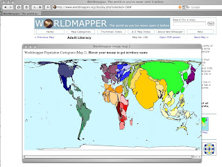
  • Worldmapper offers world maps "where territories are re-sized on each map according to the subject of interest." The maps use color to divide the world into 12 geographic regions to make comparison easier. The maps are "equal area cartograms" or "density equalising maps" which resize territories based on single variables or subjects, like adult literacy in the picture at the head of the post. Maps cover subjects like land area, population, primary education spending, dairy imports, oil depletion and water use. These seem like great ways to show differences between regions or developing and developed nations.
  • The United Nations, along with the expected reports and international information, hosts Cyberschoolbus. At Cyberschoolbus, teachers can find data and statistics on UN Member States and curricula on peace education, human rights, discrimination, poverty and hunger. In March, students were invited to send questions to Secretary-General Ban Ki-moon; answers won't be up for several weeks but the question page has some great pages offered as background for student questions. Regular podcasts are also available.
  • The Central Intelligence Agency (CIA) World Factbook has reference maps, country profiles, rank order pages, flags of the world and more. You can search the factbook at the website or download it for free (with tips for high-bandwidth and low-bandwidth users). Factbooks from 2000-2007 are also available. A quick search of the CIA site can locate other maps and publications that are free to download. Imagine the student buzz over looking at (unclassified) CIA information.
According to Judith Bock, a teaching consultant who helped found the Illinois Geographic Alliance, the main obstacle in this geography information revolution is the technological savvy needed to find, access and use the great tools available. With these excellent geographic resources, students can look at the world as it is -- multifaceted, dynamic and always fascinating.

SOURCE: " ‘Real Essence’ of Geography Ed. Is Online, Experts Say" 04/03/08
photo: screencapture of the Worldmapper home page and Adult Literacy map popup

Tuesday, February 26, 2008

Eighth Graders Mapping a Safer Neighborhood


A new addition to the technology and social studies curricula at Spain Middle School in Detroit has students mapping their neighborhood with Geographic Information Systems (GIS) software.

In a program called Mapping Out a Safer Community, run by the Urban Safety Program of the Wayne State University College of Urban Labor and Metropolitan Affairs, college faculty train eighth-grade students at Spain Middle School to use GIS software and PocketPCs to map various hazards in their school's neighborhood. The project, as reported by Ellen Delisio in Education World, is intended to help students learn about and advocate for their neighborhoods.

At the Wayne State University Taking Stock of Neighborhoods web page, the project is further described:
Using PocketPCs, students map locations and characteristics of dangerous properties, take photographs, and research property ownership. They also set priorities and identify the most problematic locations near their school. Properties with the most egregious violations, known as “The Dirty Dozen”, offer a compelling picture of hazards Detroit children face daily. This information is presented to community leaders and city officials who attempt to correct dangerous situations.
The computer technology teacher at Spain Middle School, Debra Blocker, said the program gives "students an awareness of their community and their surroundings and how they can improve it and be involved." Lessons in technology are combined with lessons in civics, geography, local government and community activism. For example, Global Positioning Receivers attached to the PocketPCs give students in the field precise locations, especially important for problem properties that may have no visible or clearly indicated address. Identifying an address is the first step in finding an owner, says David Martin, a research professor at Wayne State who has worked with Spain students.

In addition, students get to see results of their field and classroom work -- students prepare PowerPoint presentations for the city council and see change happen. In one case, students presented data that clearly showed a 50% increase in abandoned houses in one neighborhood alone, prompting county prosecutors to increase enforcement in the area. This hands-on aspect to the program makes it a popular one, says Blocker: "They get excited when they see their streets on the Internet, and can identify different landmarks. It gives them a different way to address problems. We have full attendance on those days."

Interactive Adobe Scalable Vector Graphics (SVG) maps from the middle school project can be found at the Wayne State University website. ESRI's website offers more information on GIS and mapping software. Try the link especially for educators.

SOURCE: "Students Map Neighborhoods With GIS" 05/30/06
SOURCE: "Taking Stock of Neighborhoods: Geographic Information Systems Capacity Building"
photo courtesy of Phanatic, used under this Creative Commons license