The Internet has totally changed the teaching of geography and may be key to re-sparking student interest, especially middle schoolers, in geography as "much more than filling in country names on a photocopied map." Michelle Davis reports in Digital Directions on the changes in, potential of, and online tools available for geography education.
What's available online ranges from geographic information systems (GIS) to map-creation programs to much of the same data available to government officials around the world. Students can see videos and pictures, read local newspapers, and use GIS-based sites to "layer information" to examine local, national, or global trends and issues, like clean water, greenhouse gas emissions or crime statistics. These tools, according to Jan Smith, president of the National Council for Geographic Education, show students what "all geographers know," that "the world is really a dynamic, changing place." These resources appeal to visual learners and expose students to expert-created information.
The National Geographic Society is a natural place to start. Davis' article lists some other sites, including the following:
- Nationalatlas.gov is the National Atlas of the United States and replaces the paper copies made since 1970. All you need to use the site is the Shockwave plug-in for your browser. The data on Nationalatlas.gov is culled from several Federal agencies. You can find maps and layers dealing with climate, geology, water, transportation and more. Printable maps are available. If you already have a GIS, you can order map layers for free.
- The United States Geological Survey offers resources for K-12 education, splitting middle school between primary grades (K-6) and secondary grades (7-12). Teachers can find complete teaching modules, class activities, and websites for images, videos, animations, 3D tours and more. Map resources and databases are available, like the Education Map Catalog and the National Map. An information sheet (PDF) explains the research on and actual uses of GIS in K-12 education for new teachers or teachers new to GIS. And the USGS has a podcast series with "straight science insight on natural hazards; climate change; satellite imagery and monitoring; water quality; human health and wildlife disease; and much more."
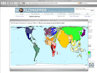
- Worldmapper offers world maps "where territories are re-sized on each map according to the subject of interest." The maps use color to divide the world into 12 geographic regions to make comparison easier. The maps are "equal area cartograms" or "density equalising maps" which resize territories based on single variables or subjects, like adult literacy in the picture at the head of the post. Maps cover subjects like land area, population, primary education spending, dairy imports, oil depletion and water use. These seem like great ways to show differences between regions or developing and developed nations.
- The United Nations, along with the expected reports and international information, hosts Cyberschoolbus. At Cyberschoolbus, teachers can find data and statistics on UN Member States and curricula on peace education, human rights, discrimination, poverty and hunger. In March, students were invited to send questions to Secretary-General Ban Ki-moon; answers won't be up for several weeks but the question page has some great pages offered as background for student questions. Regular podcasts are also available.
- The Central Intelligence Agency (CIA) World Factbook has reference maps, country profiles, rank order pages, flags of the world and more. You can search the factbook at the website or download it for free (with tips for high-bandwidth and low-bandwidth users). Factbooks from 2000-2007 are also available. A quick search of the CIA site can locate other maps and publications that are free to download. Imagine the student buzz over looking at (unclassified) CIA information.
SOURCE: " ‘Real Essence’ of Geography Ed. Is Online, Experts Say" 04/03/08
photo: screencapture of the Worldmapper home page and Adult Literacy map popup

No comments:
Post a Comment